

Major Series in Season 3 📎
Adventures in Armenia 🇦🇲
Deep Dive into Georgia 🇬🇪
Adventures In & Around Mexico City 🇲🇽
Assorted Adventures in Los Angeles 🇺🇸
Deep South: Mississippi Delta 🇺🇸
Bay Area: SF, Napa, Point Reyes 🇺🇸
Heading West: Seattle & Denver 🇺🇸
British Columbia Deep Dive 🇨🇦
PDX + Central Oregon 🇺🇸
Lots of Street Art 🎨
Featured Articles From Season 3 ⭐️

This many mountains is just insane to me. Prior to this trip, this was not what I pictured when I thought of Oregon. This was downright RUGGED! And it was gorgeous. The three mountains in closest proximity to Black Butte, and to one another are the Three Sisters for which this area is named: Middle Sister, North Sister, and South Sister. All three of these mountains are sleeping volcanoes. The North and Middle Sister last erupted ~14,000 years ago and scientists think it’s unlikely that they’ll ever erupt again. However, the South Sister erupted as recently as 2,000 years ago, and could feasibly erupt again. There have been sporadic reports of volcanic rumblings deep within South Sister since 1866, and there have been a couple of minor scares since the late 1980s. Nothing has ever happened, but there is a big pot of magma a few miles beneath the peak of South Sister. Did I mention that South Sister is also the easiest of these mountains to climb? Sign me up for that!! 😵
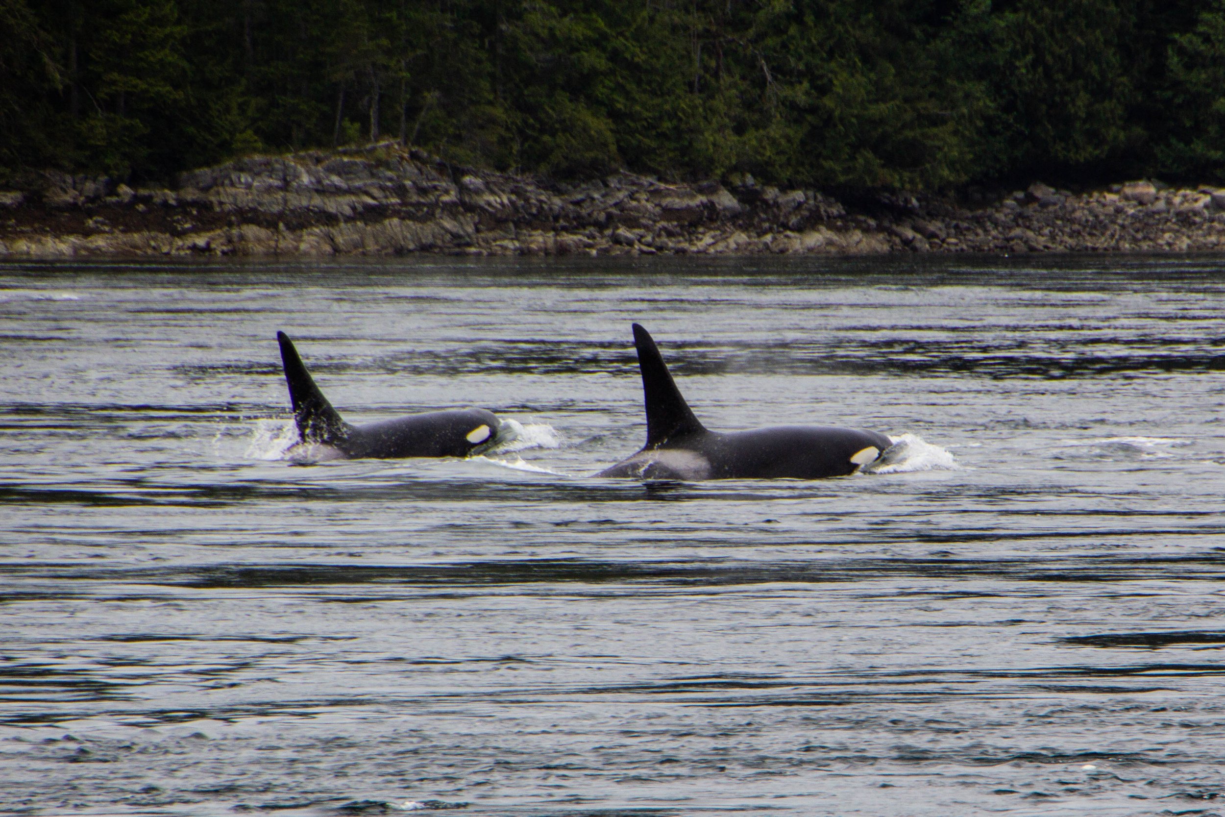
Orcas, or Killer Whales, were something of a feared creature in the olden days. Apparently, back in the 1800s when this part of the world was first being explored by Europeans, their technical/scientific classification was actually “Monster.” Hilarious as this might seem, it does make some sense. Black whales with sharp teeth and shark fins? Yeah, that would have definitely felt somewhat monstrous to me if I was an early sailor of these waters. The conventional wisdom of the day was that, if you fell in the water, you needed to get out ASAP so an Orca wouldn’t eat you. If you hadn’t already guessed this, there is, in fact, no record of an Orca ever eating a human. But this was still a legitimate fear as recently as the 1960s when they actually mounted a machine gun on a coastal bluff known as Chatham Point with the aim of shooting as many Orcas as possible. 🤯 Somehow, for the time when this gun was actively scouring the seas, the Orcas stayed clear of this area and there were no casualties. So Orca/human tensions have never escalated to be anything more than a cold war. And it was not long after this that human sentiments toward Orcas began to change for the better.

Cortes Island is perfect. I am not speaking figuratively. Literally perfect. Every little detail of this island was so effortlessly interesting, unique, and authentic… I don’t know that I have ever seen a place quite like it. It felt like I was living in a chapter of a book. It was like the entire place was straight out of a Wes Anderson movie. Think Moonrise Kingdom, but on an island off the coast of British Columbia, and mostly populated by adults. I could make a cool Pacific-Northwest-meets-Martha’s-Vineyard Pinterest board inspired by this place. Every property was tastefully weathered and clearly maintained with a personal, practical touch. There were no houses that screamed “VACATION RENTAL” here. Every single one of them looked like they were the active, primary residence of an eccentric gardener.

Avatar Grove is well-named; it really does feel like something out of Avatar. Or maybe Jurassic Park. It is a tangled, mossy labyrinth of ancient, knotted trees rising out of an infinite carpet of prehistoric-looking ferns. Each tree branch is draped with moss, similar to the way Spanish Moss hangs from every tree in Savannah—but in a green, lush, distinctly Pacific Northwest kind of way. Every little detail of this place was fascinating and photogenic. From the mossy, leafy forest floor, to the canopy high above our heads, every inch felt like its own world.

We already talked about how close into the mountains Vancouver is. I have never seen anything like it—at least not for a city as big as this. Northern Vancouver is literally built into the sides of the Cascades, with its streets and buildings sloping up the sides of the mountains as far as physics will allow. So when you start driving northward from Vancouver, you will find yourself in the mountains pretty much instantly. The drive up follows the coastline of a rugged Pacific fjord that comes to a head in the gorgeous little town of Squamish, and from there it’s all mountains. Here’s a map of the trip. It might not look like a huge distance on the map, but’s 2.5 to 3 hour drive to get up there from Vancouver.

Say what you will about Vancouver—there’s no debating that it makes an impression on you. Its iconic glittery, sparkling, glassy skyline set against a backdrop of imposing, snowcapped mountains and moody gray skies is nothing if not striking. But there’s a lot more to this place than whatever this image conjures up for you. Vancouver is an unlikely swirl of old and new, of chic and grit, and of sun and rain. And it will serve as the base camp for our next series of articles.

You can’t actually drive all the way out to Tomales Point. There’s a parking lot and a trailhead next to the historic Pierce Ranch. From there, it’s a 9.4-mile round trip hike to get all the way out to the tip and back. Over the course of this route, there’s a total elevation gain of 1,177 feet. Honestly, it’s a pretty easy hike. I did this when I was fresh off a particularly rough COVID infection, still trying to get my mojo back, so this should give you no pause.

San Francisco is not a flat city. The word “hilly” doesn’t quite cover it. So it should come as no surprise that there are lots of interesting staircases (600+) scattered throughout the city, helping pedestrians scale the city’s steepest nooks and crannies. This much is to be expected. But what I did not expect was that many of these staircases have been turned into hidden works of art. I’ve been to San Francisco a few times, and I have somehow never stumbled across even one of these before. And what you’re about to see isn’t even all of them! We’re going to start in the Richmond District, but then we’re going to head south and spend the rest of this article in the Sunset District.

And we’re back in mainland Seattle from our little trip over to Bainbridge Island! In our first installment, we checked off some of Seattle’s more obvious tourist attractions (i.e. Pioneer Square, Pike Place Market, the view of the Space Needle from Kerry Park, etc.). It was very cool, but TODAY we’re going to peel a few more layers off the onion and get into some of Seattle’s quirky b-list attractions. As a city, Seattle has a stronger and more distinct personality than most. I think this cross-section of less-notable items actually did more to help me get to know this place than the major tourist attraction did. It’s all about details.
SO LEMME HITCHU WITH THE DEETS.

Some places hit you with vibes the second you step out of the airport. The air is different. The energy is different. Even the industrial in-between areas around the airport and the highway have a strong sense of character. Seattle is one of those places. In a happy twist of fate, I unwittingly ended up on the same flight to and from Seattle as one of my buddies in BNA, so I got the express pass into the city riding shotgun in the car that he had rented. Seeing the breathtaking Cascadian landscape unfold before us, I could not stop talking about how cool it all was. The mountainous terrain makes it so you are always either arriving at or leaving from a scenic vista, each of which provides a more gorgeous view than the last. Looking out in any direction, there are always multiple layers of water, city, and evergreen-dominated foothills between you and a background of MUCH larger mountains. And those mountains are always set against an expressive sky, which alternates between a clear, northerly baby-blue color, or a swirling moody mass of clouds.
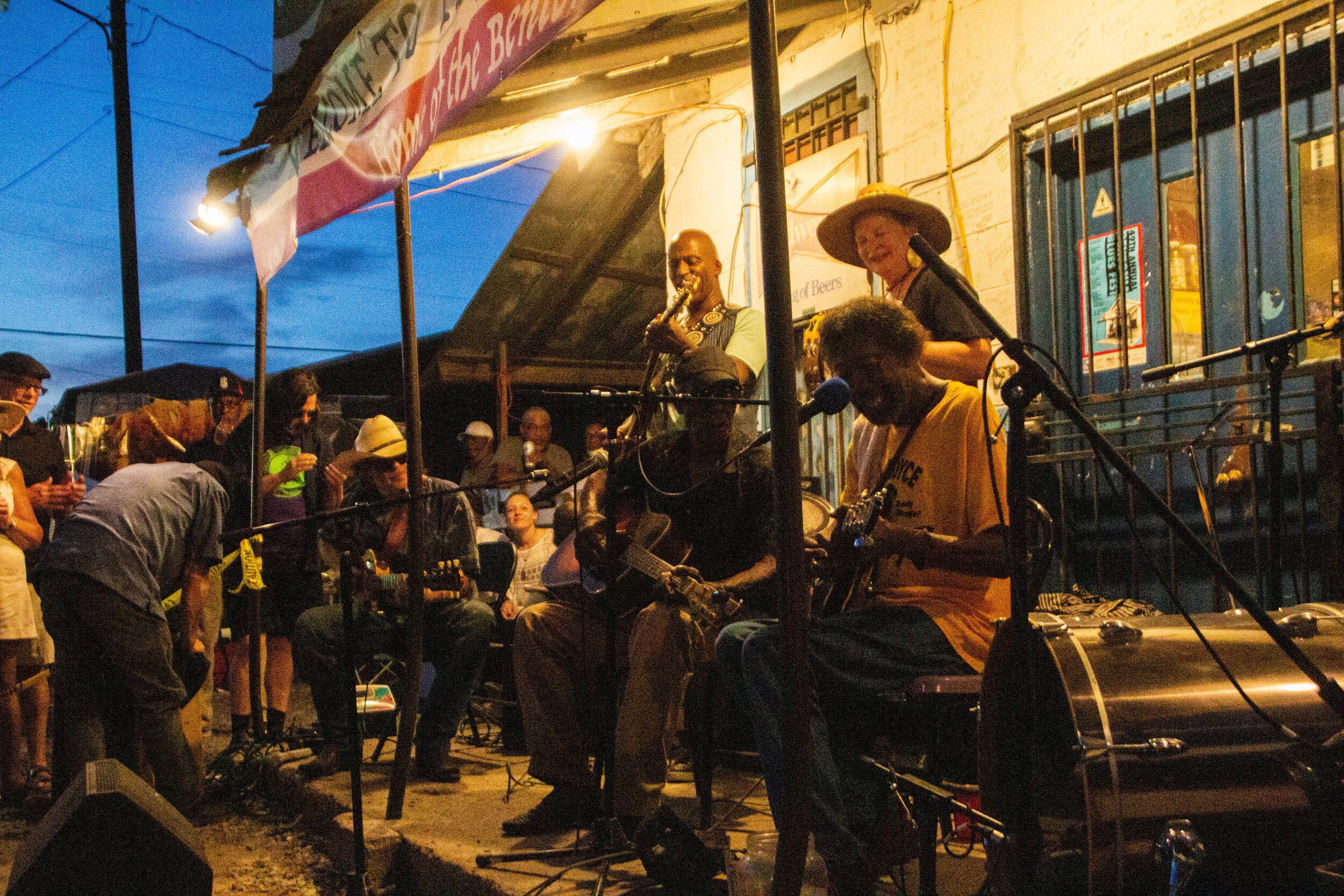
I don’t know what I expected when I showed up in Mississippi. I had some vague aspirations about getting out into the legendary Delta to see pieces of the Blues Trail, but I wasn’t sure how realistic it was to cover all of that ground in the short time I had. I thought it would be cool to visit the Crossroads, but everybody I know that has been there told me it’s literally just an intersection in the middle of nowhere. So I wasn’t sure it was worth the drive. This probably doesn’t sound like the beginning of a great article. I really thought of the Blues mostly in the past tense so I wasn’t expecting to find anything in Mississippi but some history. But OHHHHH MAMA! I have never been more wrong in my LIFE!

The observatory was/is equipped with a 12-inch Zeiss refractor telescope that you can actually go look through. Since 1935, an estimated 7 million people have looked through it to catch a glimpse of the stars, which makes it the most used telescope in history by far. In WWII the planetarium was used to train pilots in celestial navigation. Later, in the 1960s, it would be used for that same purpose as a part of the NASA space program. In 2002 this place underwent a major renovation mostly focused on its visitor-facing amenities. Now there’s a café, a gift shop, and a movie theater. I’m sorry to tell you we’re not going into much of this stuff today though. We’re here to catch the sunset!

It was our first full day in Mexico City, and we were sitting in a coffee shop somewhere along the boundary line between Condesa and Roma trying to figure out what we should do with the rest of the time we had. I’m not great at planning my travels in advance, so these sorts of on-the-go brainstorms happen in just about every new city I visit. I wondered aloud if there was any Lucha Libre wrestling to be found here. “I mean, this is the literal center of everything Mexican, so it’s gotta be here somewhere, right?”
At that exact moment, we heard somebody say “Excuse me.” It was the man sitting next to us. He had overheard us talking. In perfect English, he proceeded to tell us everything we could have ever wanted to know about Lucha Libre wrestling in Mexico City. “It’s so fun! I go like every week!” he said emphatically.

Teotihuacán is one of the most historically, culturally, and architecturally significant cities in the pre-Columbian Americas. At its height, it was the largest city in both North and South America, with a population of 125,000 people (estimated). That might not seem like much today, but by Mesoamerican standards, that’s like Tokyo or New York. This wasn’t just a place—it was THE place. But here’s what makes it so fascinating…
The origins of Teotihuacán are utterly mysterious. The backstory behind its founders is totally unknown. And it’s not just unknown to us now, in 2020. Apparently the Aztecs discovered the ruins of this city and also didn’t know exactly where it came from or what the story was. Isn’t that INSANE? The AZTECS discovered this when it was already ruins!

Let’s start with size. Mexico City is really, really big. In fact, Mexico City proper has almost 9 million people and Mexico City metro is home to a whopping 21 million people, which just a few million less than Beijing. This makes it the largest population center on the entire continent of North America—bigger even than New York, LA, Chicago, Toronto, etc. It also puts Mexico City comfortably in the top 10 largest cities in the world.

Literal paradise.
Ushguli is a small cluster of towns that sits right on the Georgia-Russia border in the mountainous northerly region of Svaneti. It’s remote, difficult to access, and it’s got a population of less than 250 people. And yet, a quick Google image search for Georgia (the country of Georgia) will often return images of Ushguli even above images of the capital city. Clearly there is something special about this place.

Svaneti is the highest inhabited region of the Caucasus mountain chain. The whole region is studded with snow-capped 3,000–5,000 meter (~10,000–16,500 foot) peaks and sprinkled with small glaciers. In fact, the highest mountain in Georgia, Mount Shkhara, is located here in Svaneti, which stands at 5,201 meters (17,059 feet) tall. But in between all these mountains and glaciers are some of Georgia’s most picturesque little valleys and towns. These town are inhabited by an ethnic group known as the Svans.

Finally, we arrived at our destination. Before we re-enter our narrative, let me introduce you to the famous Georgian mountain town of Kazbegi. It’s basically just famous because the mountain peak that towers over this little town is particularly dramatic and maintains a snowcap year round. This Mount Kazbek. In short, it’s super pretty! Everybody I had brushed elbows with up to this point in my trip recommended Kazbegi profusely.

Some cities hit you with strong vibes the minute you step out of the airport, and those vibes set the tone of your entire stay. But Tbilisi was an interesting one, because I really didn’t feel anything when I arrived here. Or ever, in the 7 nights I spent in this city. I was expecting some sort of strong, emotive, post-Soviet energy of a fledgling nation determined to get on its feet regardless of Russia’s endless attempts to undermine its sovereignty (or, you know, something like that) … but I felt nothing. Because, as it turns out, Tbilisi is a city with absolutely ZERO pretense.

It was this event that prompted the creation of the term “genocide.” There wasn’t really a word for this before the world started to do business with what happened to the Armenians. I’m going to tell you this story now, and I’m sure you will start to notice some eerie parallels with the Holocaust. In fact, the two aren’t entirely unrelated. But before we dive in, I’m going to warn you, this will be disturbing.

Once we got a bit closer to the city center, the vibes quickly became more difficult to categorize. Fast forward a few hours and I was in my happy place: out on the streets with my camera. I was eager to jump to conclusions, but the further I walked the less I sure I became of what I thought I knew. Some times I would pick up Middle-Eastern vibes from open-air restaurants in city squares, other times I would get European vibes from the little Armenian bakeries tucked away somewhere on every block. And the architecture on those blocks sometimes seemed to be European-adjacent… but then on the next block the buildings were giant, brutalist concrete blocks, serving as a striking reminder of Armenia’s Soviet past.

For my American readers, I’m gonna go out on a limb here and say that there is no way in hell that you don’t know what Napa Valley is. But for my readers from abroad, I’ll explain just in case. Napa Valley is America’s postcard wine country. There are pockets of vineyards all over the country of course (Oregon is a notable wine producer as well), but Napa Valley is the epicenter of wine culture and cultivation in America. Napa Valley refers to a large fertile valley full of vineyards in Napa County, California, which just on the north side of the San Francisco Bay. Driving north through Napa Valley, there are a few towns that you will pass through, the first of which is also called Napa. The next major towns before the northern end of the valley are Yountville, St. Helena, and Calistoga.

First off, what I’m defining as “Richmond” here is actually made up of 4 smaller districts: Inner, Central, and Outer Richmond… and a little area to the north called Lake Street. This neighborhood (or group of neighborhoods) is essentially a big grid system, which, despite occupying an extremely urban area of San Francisco, is surrounded on almost all sides by nature.
Chush Falls (pronounced “shoosh”) is actually nestled right up against the Sisters Mountains and Broken Top. The drive to get to this trailhead was about an hour from Tam McArthur Rim, all over gravel roads. Oh, and it was absolutely STUNNING. Honestly, even if you don’t do this hike, the drive is still well worth the effort. This was already bringing me closer to these mountains than I had yet been. Looking up at the snowy slopes, I could see every little rock and wisp of cloud clearly and was able to even capture some of this with my camera. And, miraculously, the weather really was clearer over here.