
Driving down from the Westfjords to the long peninsula known as West Iceland, we made an abrupt exit from the rugged tundra that had dwarfed us for the past few days, and entered a flat area of limbo between the 2 regions. Passing through these rolling green fields, both land formations (West Iceland and the Westfjords) were clearly visible. They stretched eastward for miles upon miles out into the chilly ocean wind. There have been very few times when I have felt as connected to and as aware of my geographical position as I did during this time spent driving through the ‘in between.’
About West Iceland
West Iceland (Vesturland) is a beautiful, volcanic peninsula that juts eastward out of the Icelandic coast between the Westfjords (to the north), and Reykjavík (to the south). Now, the main road in Iceland is referred to as “the ring road.” Most people who drive on this road will set out from Reykjavík and spend a week or two making the complete loop of Iceland, usually stopping in Akureyri (in the north) along their way. This is your standard trip to Iceland. However, West Iceland is not included on the ring road (nor are the Westfjords). This means that there are far fewer travelers in West Iceland, and even less traffic.
Making up the middle of this peninsula is a jagged, rocky mountain range called Snæfellsnes, which is home to a small glacier called Snæfellsjökull (remember that “jökull” means glacier). The main roads of West Iceland mostly just trace the coastline, but there are small mountain passes that lead up into these mountains. After our long journey through Sprengisandur and the Westfjords, we decided to pass on these mountain roads. We were tired. Below is an interactive map to show you West Iceland in context:
Driving In...
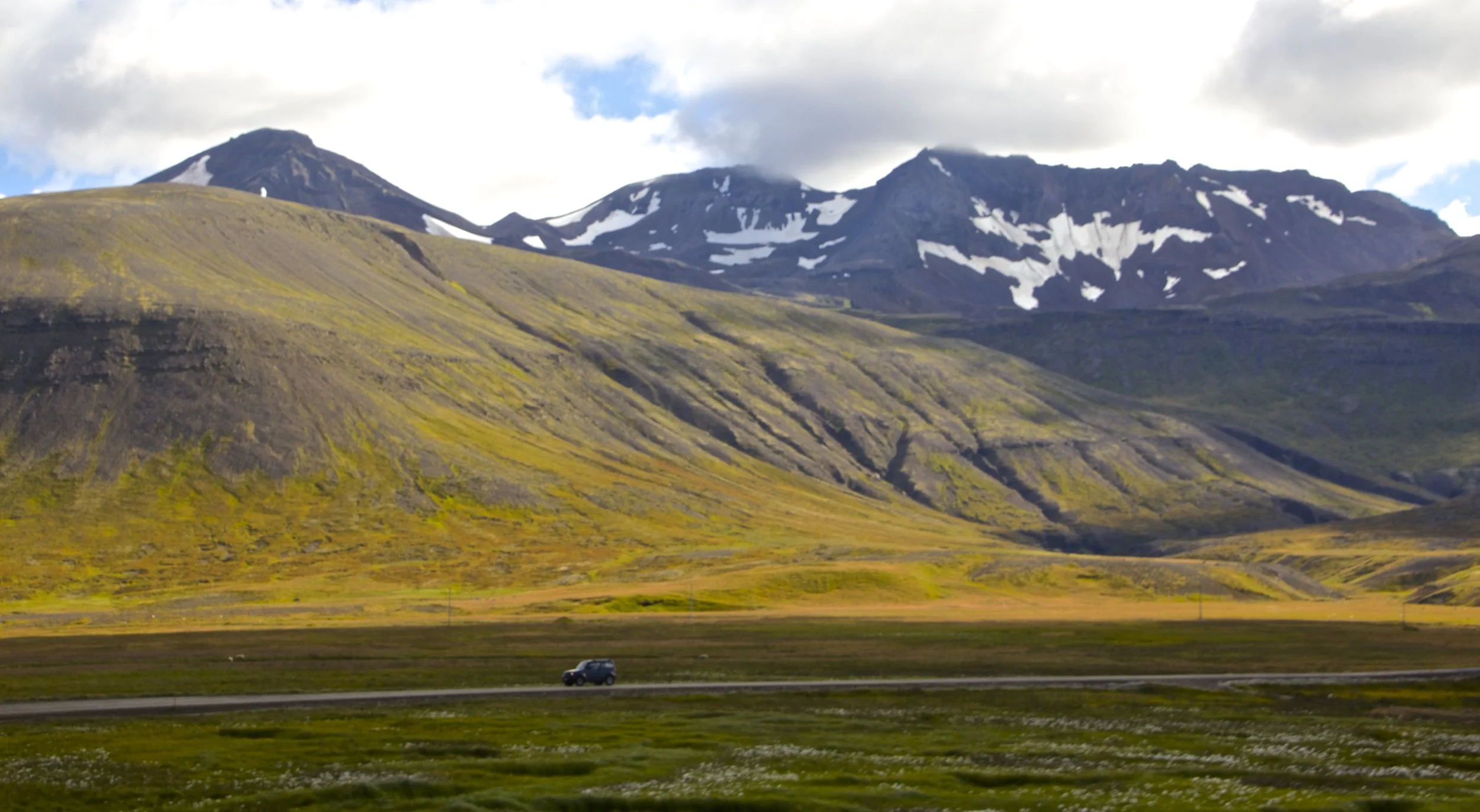
The road into West Iceland was rough and gravely. Black, jagged mountains formed an ominous skyline ahead of us. These mountains were on an entirely different scale than human life. It seemed that no matter how long or quickly we drove, we weren’t getting much closer. As we inched our way closer and closer, the immensity of Snæfellsnes was making me feel pretty small by comparison.
As we got closer the visibility of this mountain range eventually began to fade until, finally, we turned a corner and BANG! We were in the middle of it. The following hours of driving were nothing short of breathtaking. Our road wove along mountainsides, across lakes, and flirted with the rugged Icelandic coastline. Occasionally tiny clusters of houses would appear on our horizon, but it would usually take less than 60 seconds to drive all the way through these little towns. The Snæfellsnes peninsula is pretty sparsely populated.


Our first destination in West Iceland was a mountain called Kirkjafell. This mountain is located at, roughly, the halfway point of the northern side of the peninsula.
Kirkjafell
Here’s a quick lesson in Icelandic for you…
Kirkja = Church
Fell = Mountain
Kirkjafell = Church Mountain
If you remember my “travel plans” article, Kirkjafell was my main draw to West Iceland. Everywhere on the internet I looked, I found more pictures of this odd, conical mountain, until finally my intrigue reached a tipping point, and I wrote Kirkjafell into our travel plans.
I don’t know if anything has ever been more of a letdown than Kirkjafell. I don’t know what I was picturing, but when we finally turned the corner and saw it with our own eyes, it was just so unremarkable. The town of Grundarfjörður sits at it’s base, which makes Kirkjafell seem pretty huge if you take a picture of it from the right angle, but in real life, it’s absolutely dwarfed by the Snæfellsnes mountain range, which sits right next to it. Kirkjafell is really nothing to write home about.
Nevertheless, we pulled off into the small gravel parking lot, which was situated almost on the slopes of Kirkjafell, unceremoniously. From there, we walked across the road to Kirkjufellsfoss (Kirkjafell waterfall). The waterfall is the necessary second ingredient for any clichéd travel photo of Kirkjafell. I took a few photos in between groups of Chinese tourists walking through my shot, and then we walked back to our car to move on. Here are those photos, for what they’re worth…


I will concede that this mountain is pretty damn photogenic. Every time I publish an article, I have to make a tough call about what I want my "featured image" to be (the image you see up top), and Kirkjafell just looked the best. So I guess I'm perpetuating this fraud now.
Sorry!
Moving on...
Snæfellsjökull National Park
Moving past Kirkjafell, the terrain grew steadily harsher. The rocks were sharper. The coastline was more jagged. The vegetation on the ground grew sparser. The mountains to our left became more immense. Eventually I began to catch glimpses of Snæfellsnes’s famous glacier atop these mountains. Furled in clouds, visible only between the black, rocky outcroppings, was Snæfellsjökull.
Here’s another lesson in Icelandic for you:
Snæ = Snowy
Fell = Mountain
Jökull = Glacier
Nes = Peninsula
Snæfellsnes = Snowy Mountain Peninsula
Snæfellsjökull = Snowy Mountain Glacier
Super creative, right?
Icelandic has a lot of big words so it looks really hard, but those are actually just a bunch of smaller words smushed together, the translations of which never fail to disappoint. Pronunciation is near impossible though.

The appearance of Snæfellsjökull meant that we were entering Snæfellsjökull National Park. And in spite of the boring translation, Snæfellsjökull is actually the source of some intrigue in Iceland. According to Icelandic lore, Snæfellsjökull Glacier is one of the 7 great energy centers of planet earth, the byproduct and home to mysterious, magical powers. It is also the setting for French author Jules Verne’s classic science fiction novel, Journey to the Center of the Earth. In this book, an Indiana Jones-esque German professor descends through ancient volcanic tubes in Snæfellsjökull to find prehistoric creatures and other crazy things… but I didn’t do anything like that. My trip was pretty tame, comparatively. We stayed pretty much at sea level and didn’t climb up to the actual glacier (although, now I really wish we had).
Here’s some photographs from driving into the park…


Into The Volcano
Snæfellsjökull National Park sits on the very tip of the peninsula that juts out from West Iceland into the Atlantic. Driving along side of Snæfellsnes, arriving here feels kind of like the 'grand finale.' Here's the map for your reference...
Upon entering National Park, we found ourselves driving through a volcanic plain that separated the sea from Snæfellsjökull. Clearly, at some point long ago, lava had flowed across these roads. The dried grooves running down the side of the mountain gave way to a jagged hell-scape of sharp rocks, black sand, and strangely colored varieties of moss.
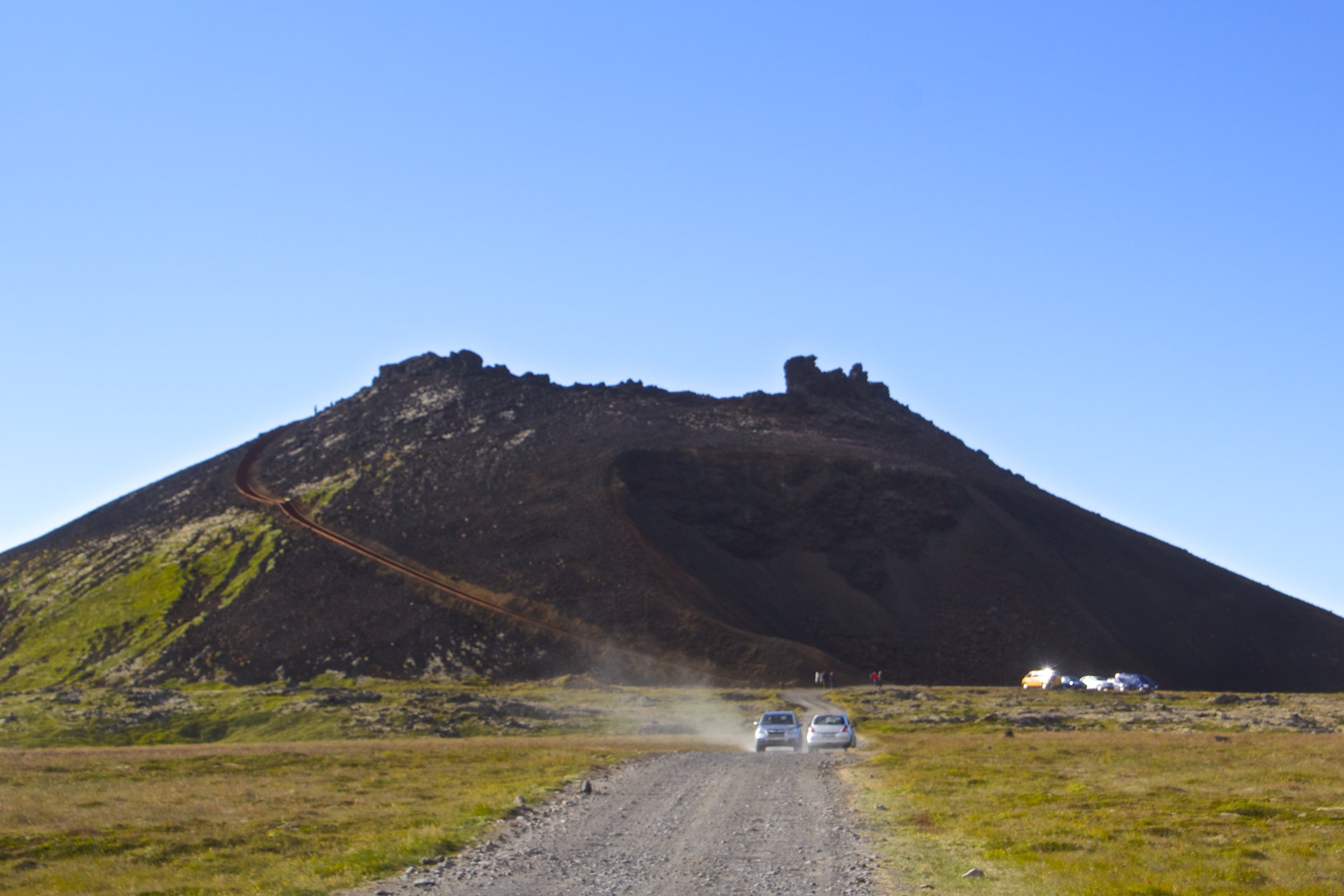
Off to our right, we saw a tiny volcano with a path going up the side, so we decided to turn off. Once we got closer to this volcano, we discovered that it wasn't so tiny after all. The trail that took us up into the caldera was a difficult climb! When we finally got to the top, we found ourselves on the edge of the volcano's dormant caldera. This was a relatively small volcano, and even though it was now covered in moss and buried in gravel, its caldera was a gaping maw. Just imagine what it would be like to look into the caldera of Kalta! (That's Iceland's biggest volcano)
We took in the geological significance while we caught our breath, and then we returned to the car. Onwards!


Sea Front
From there, we drove further through Snæfellsjökull National Park. Along the side of the road, there were no shortage of places where we could pull off to explore. Once we got off the road, we were wandering through a rocky forest. Razor-sharp, wildly jagged rocky columns shot up all around us. They were porous and sharp in a way that if you brushed against them, your shirt would definitely rip. It was an otherworldly landscape.
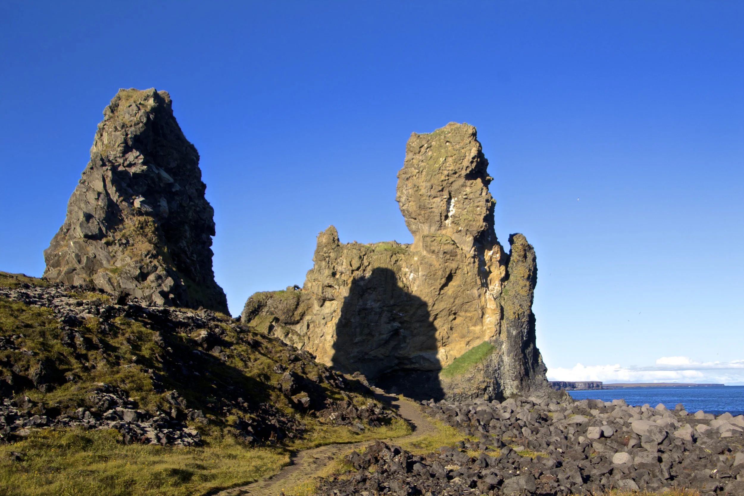
The first time we stopped pull off the road to hike through this rocky forest, it was a short walk to the "beach." The beach here actually turned out to be a rocky cliff overlooking a small area of black stones. As the tides washed over these shores, the stones would rub together, making a sound reminiscent of a rain stick. Looking further out down the coast, we spotted particularly large rocky spires protruding from the ground. They couldn't have been more than a mile away, so we hopped back in the car and drove in their direction.


After we parked our car, it was a long hike through thick fields of wild grass before we returned to the rocky landscape that had defined our previous stop. As we approached these rock towers, they seemed to be growing in size. These towers were much bigger than we had thought! Eventually we reached our targets and sat down in between them to rest for a while.
This was pretty much it. We had made a long and winding journey through Iceland, and this was our last stop. It might not look like it from these photos, but this was like 8:30pm when we finally reached this place (#midnightsun), so we were tired. It was time for us to go find our guest house, but before we set off, I took a moment to soak this place in. I inhaled the cool, salty breeze. I felt the sunlight warm my bones through the cool, crisp air. I listened to the waves crash on the rocks below us. I felt the wild grass in my fingers. Soon I'd be headed back home, to hustle and bustle, but this place was going to stay quiet and serene forever.
Sigh.


Our Guest House
Bodvarsholt

Trying to find a place to stay in West Iceland turned out to be pretty difficult. It didn't help things that I had waited until 48 hours beforehand to make reservations. By that point, pretty much everything was booked except for a guest house / hotel called Bodvarsholt. So our choice was clear. Before I arrived here, I wasn't exactly thrilled with the prospect of staying here. In our confirmation email they said that the closest place to get food was almost 30 minutes away, so we should plan on using their kitchen. That was disconcerting for me, but we had no choice.
Once we finally arrived at Bodvarsholt, all of my uneasiness about it faded away. Yes, it was isolated. But Snæfellsnes itself is so sparsely populated that in order to avoid complete isolation, you pretty much have to stay in one of the 2 tiny towns that even exist out here, and that sort of defeats the purpose of coming to a place like this. Bodvarsholt was a cozy little place. Their kitchen was very nice, and the staff was a pleasure to interact with. The next day we would make our final drive, back to Reykjavík, so I was happy to be able to sit outside and look at these northern stars one last time (during the 2 hours of night time that we had at our disposal). It cold and quiet out there. The stars shined brightly over the massive mountains which slept peacefully beneath them. I was going to miss Iceland.
Driving Out...
Heading south, we drove through the southern side of Snæfellsnes. It wasn't long before we had exited the mountains of West Iceland and entered the limbo area between Snæfellsnes and Reykjavík. However, unlike the barren wasteland that lies between the Westfjords and West Iceland, in this case we immediately found ourselves on huge, multi-lane highways. There were toll booths, tunnels, traffic, and exhaust. Welcome back to society! Here's a picture looking southward across Faxa Bay...
From here it was a relatively short drive back to Reykjavík. Looking out across Faxa Bay, I could see Hallgrímskirkja towering over the city. I rolled back into that Reykjavík with much more of an appreciation for it. When I first arrived, it seemed like sort of a precarious outpost for humans to occupy... But after driving to hell and back, Reykjavík may as well have been Los Angeles. It felt good to be back in society, but the landscapes I saw and the people I met in Iceland will stay with me forever, and continue to shape my view of the world around me.
From here, I would eventually drive back to Keflavík, and fly out. I was sad to leave Iceland, but don't worry. I still have a couple things to share with you from my travels here, starting with food.
Stay tuned to watch me eat a sheep's eyeball.
Fun fact: When this album (below) was released in 2012, it broke almost every music-related record in Icelandic history. At this point, it is estimated that 10% of Iceland's population owns a physical copy of this album. And who buys physical copies of albums anymore?