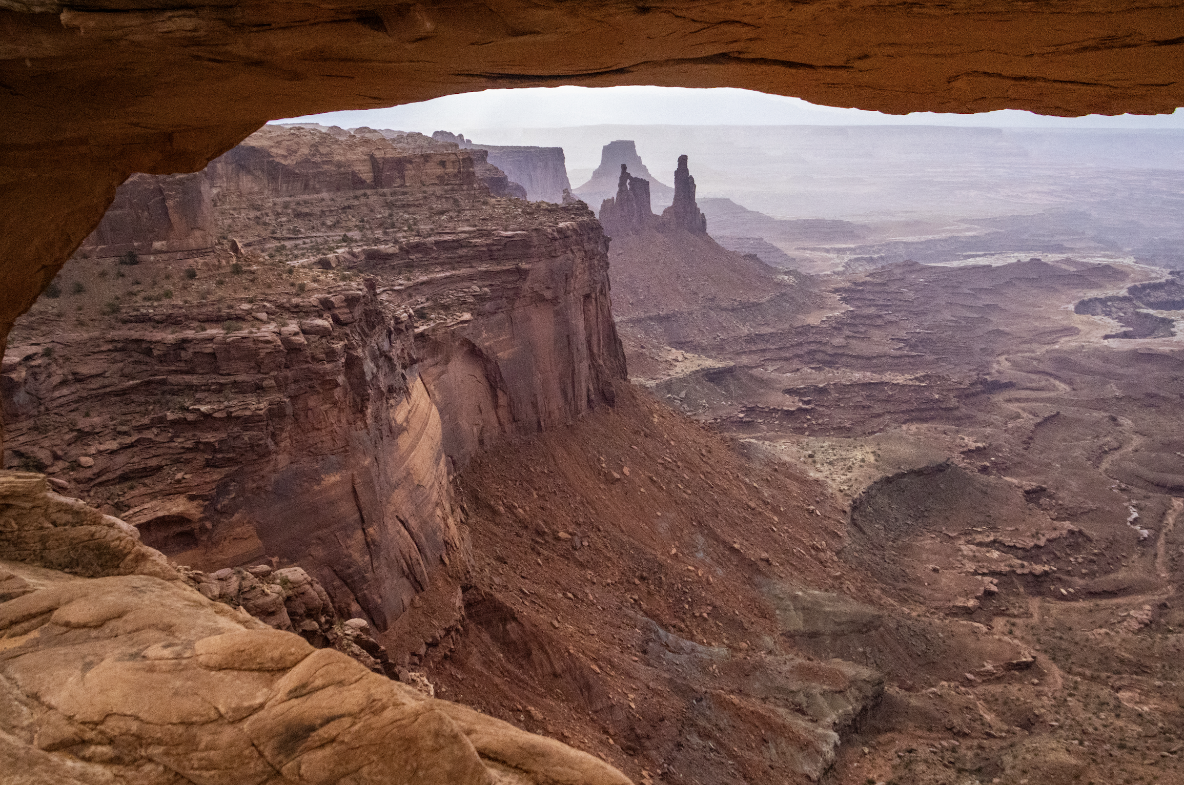
Finally, we arrive at Canyonlands National Park, which is the largest and most remote place we will visit on this trip by far. A couple hours southwest of Moab and Arches, Canyonlands spans an area of more than 300,000 acres. It is not a place that can be seen fully in a single day… but we’re going to do our best. Indeed, this particular trip will be most confined to the northern regions of the park, but I want to underscore that there is a LOT more of this landscape that we won’t see today.
As you will see, Canyonlands is a VAST area of canyons carved by mighty rivers that still flow through them to this day. Thousands of feet above the water, towering mesas look out across seemingly endless canyon-scapes. It offers more than a few STUNNING views.
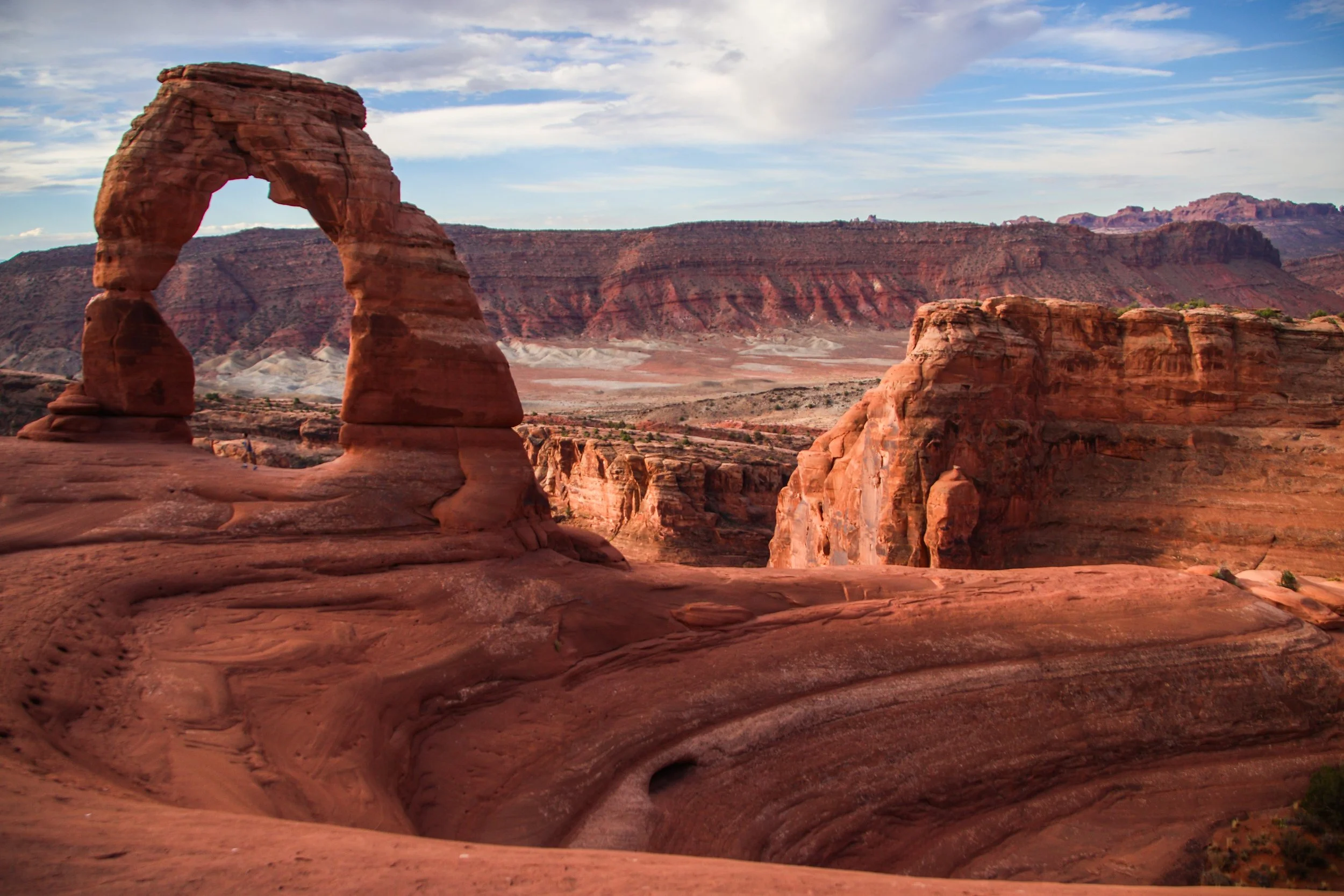
There are lots of famous rock formations in Arches National Park, but the most famous of them all is called “Delicate Arch”. We wanted to get there early in the day and experience sunrise within the park, which meant that we have to get moving at the butt-crack of dawn. In the gentle early morning light, our rental car carried us out of Moab and up a steep switch-back road into the park. Mind you that Moab is already ~4,025 ft (1,227 m) above sea-level. Arches actually gets as high as ~5,653 ft (~1,723 m) above sea-level, and—despite being only ~5 miles (8 km) away from downtown Moab—is usually 5–10°F (~3-6° C) colder. That being said, both Moab and Arches get HOT in the summer. The record high in Moab was 114°F (~46°C), and summer highs frequently exceed in 100°F (38°C) within Arches. So, heat is a hazard here! Consequently, sunrise/sunset exploration tends to be preferred, with many visitors retreating to Moab for a nice air-conditioned siesta in the middle of the day.
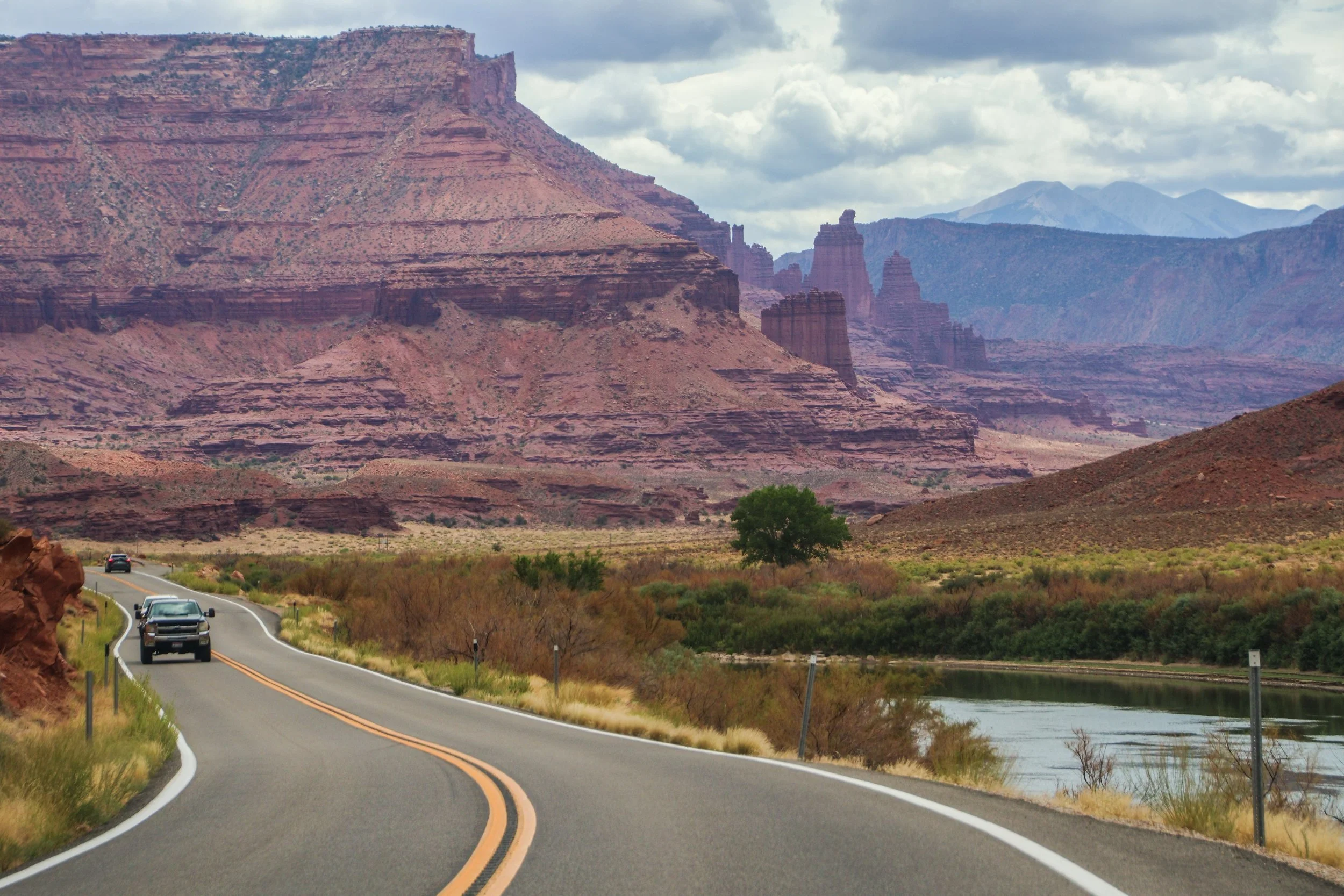
The road you are about to see was an important regional access point long before Moab was ✨M0aB✨—it was (and still is) important for ranching and river access. AND, it was apparently an important area for Uranium mining in the mid-1900s. But the human element of this road is really besides the point; unlike the rigid grid systems you will find in a lot of US infrastructure, this road works with nature, snaking through this canyon, following the river wherever it goes. In this sort of geography, you’d really have no choice but to build this road this way. That’s one of the magical things about traveling out west: the natural features become far too big for humans to tame.
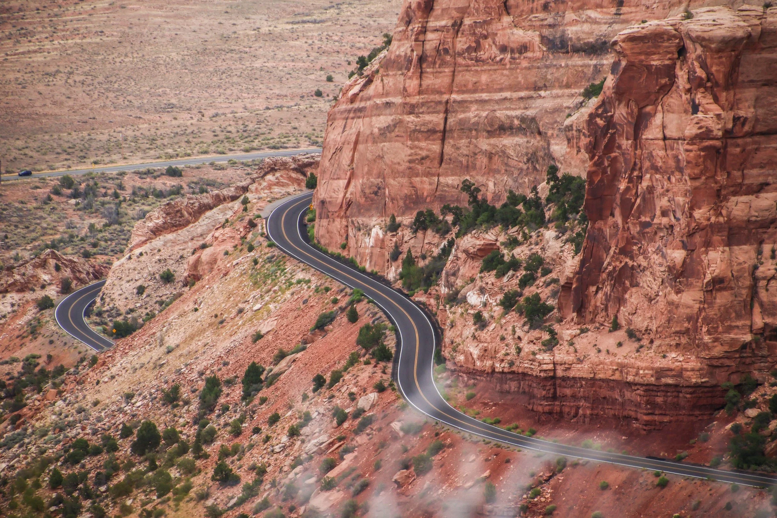
Colorado National Monument isn’t a single landmark, but a large area of landscape, which includes massive rock formations, deep canyons, and rugged plateaus, all of which were carved over millions of years by wind and water. The primary thing to do here is the Rim Rock Drive, which is a 23-mile-long paved road that brings you past a great many breathtaking views over dramatic sheer cliffs and expansive valleys. There are lots of places to stop along the way, many of which have their own hiking trails and camp sites. Today, we’re going to drive the Rim Rock Road.
Whether or not these kinds of country bars are “your scene,” there is one thing that can be said for certain about Nashville’s Honky Tonks: they are the genuine artifact. Almost anywhere else you would encounter this kind of atmosphere, it would be a rip-off of something else. But THESE bars are the O.G.s. It was here that the “Father of Country Music” Jimmy Rogers started playing at bars almost a century ago in the 1930s. The area has gone through some ups and downs over the past 100 years, but today Broadway is enjoying multiple consecutive decades of economic growth.
Yes, if the articles on the Internet are to be believed, Music City is the place to be! Over the past few years, it has become an oft-recited fun fact that more than ~100 people are moving to Nashville each day. I can guarantee you that almost every single one of these people knows Nashville’s nickname, ‘Music City,’ and will visit Broadway—and maybe even the nearby Country Music Hall of Fame—in the first 6 months of living here.
However, very few of them will have ever heard of the other side of this coin: Jefferson Street.
Here’s the thing about State College: it’s in the middle of goddamn nowhere. It’s notable because it’s the college town corresponding Penn State, which is one of the biggest universities in the country. And what is Penn State close to? Nothing. It’s the place that other things are close to. So we had to fly to Pittsburgh and then drive 3 hours in a rental car to get here. All that sounded like a huge hassle to me, until we got off the plane and promptly entered fall paradise. The trip turned out to be the biggest and best dose of autumn that I have gotten in a LONG time. Here are a few snapshots of the nice fall weekend that was to come.
When I arrived in Minneapolis, the one thing that I knew I 100% wanted to go see was the famous, original George Floyd mural. Ya’ll know I love street art. This is arguably the most famous mural in the world right now, so I had to make the pilgrimage. I had some vague awareness that there would be some remnants from the protests around it… but I was not prepared for what I found here.
George Floyd Square was one of the most powerful places I have ever visited. I’m not sure how long it will stay in its current form… but I hope some sort of city ordinance intervenes to preserve it this way forever. Let me show you what I saw here.
I think this post takes the cake for the farthest total distance traveled within a single street art post. These murals were SPREAD OUT. The Twin Cities is a massive place. And on this particular weekend, it was hotter than the devil’s butt crack. I hope you are reading this in a nice climate-controlled space because when I think back on this weekend… I feel sweaty.
Well, I won’t bury the lead. Let’s see some STREET ART, EH?
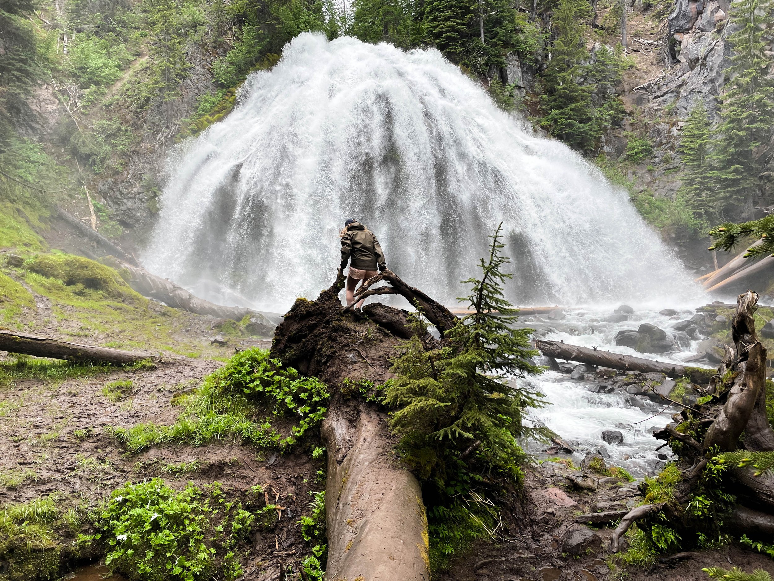
Chush Falls (pronounced “shoosh”) is actually nestled right up against the Sisters Mountains and Broken Top. The drive to get to this trailhead was about an hour from Tam McArthur Rim, all over gravel roads. Oh, and it was absolutely STUNNING. Honestly, even if you don’t do this hike, the drive is still well worth the effort. This was already bringing me closer to these mountains than I had yet been. Looking up at the snowy slopes, I could see every little rock and wisp of cloud clearly and was able to even capture some of this with my camera. And, miraculously, the weather really was clearer over here.
This many mountains is just insane to me. Prior to this trip, this was not what I pictured when I thought of Oregon. This was downright RUGGED! And it was gorgeous. The three mountains in closest proximity to Black Butte, and to one another are the Three Sisters for which this area is named: Middle Sister, North Sister, and South Sister. All three of these mountains are sleeping volcanoes. The North and Middle Sister last erupted ~14,000 years ago and scientists think it’s unlikely that they’ll ever erupt again. However, the South Sister erupted as recently as 2,000 years ago, and could feasibly erupt again. There have been sporadic reports of volcanic rumblings deep within South Sister since 1866, and there have been a couple of minor scares since the late 1980s. Nothing has ever happened, but there is a big pot of magma a few miles beneath the peak of South Sister. Did I mention that South Sister is also the easiest of these mountains to climb? Sign me up for that!! 😵