So, the “Sisters” are a series of massive hills that have each essentially been sliced down the middle by natural erosive processes to reveal massive, sheer cliffs that stretch along the English coastline like a series of rolling waves. To make the scene all the more striking, these cliffs are entirely white. Perhaps you’ve heard of the “White Cliffs of Dover”? This is part of the same system of cliffs, which is called the “South Downs”, but Seven Sisters is arguably even more iconic because the entire stretch has been kept completely natural and undeveloped. The white color comes from the fact that the earth here is made of an extraordinarily pure form of limestone: chalk! Indeed, the earth here contains about 98–99% calcium carbonate, with very little clay or sand, making them appear dazzlingly white! They stay so white because they are in a constant cycle of erosion, where after some time the outer layers of chalk crumble away revealing fresh, white chalk.
Poland’s reputation is for being an overwhelmingly flat country, and that is mostly true, but its far southern border, which it shares with Slovakia, is marked by a particularly jagged section of the Carpathians known as the Tatra Mountains. Although they are much smaller than other European mountain ranges—such as the Alps, Pyrenees, and Caucasus—they are extremely dense, rugged, and beautiful. In fact, they are SO beautiful that—although they only stretch about 57 km (35 miles)—the Polish and Slovakian sides receive a combined ~8.5 million visitors per year, skewed toward the Polish side. That makes them the most intensely visited mountain landscape per square kilometer in Europe. And yet, I’d never even heard of them before this trip!
So, what exactly is Goa? Because it’s so tiny, I was surprised to learn that it is actually a stand-alone state in India, on the same administrative level as Uttar Pradesh, Rajasthan, or Maharashtra! Indeed, it is the smallest state in India, and its modern-day borders correspond to the legacy boundaries of Portugal’s once-upon-a-time colony on the Indian Subcontinent.
We mostly associate India’s colonial period with Great Britain, but France and Portugal both had small carve-outs in South India too. When the British finally left India shortly after WWII, the newly independent Indian government had expected Portugal to pull out of Goa as well, but Salazar (dictator of Portugal at the time) had other ideas. Long story short, India reclaimed Goa from Portugal via military force in 1961. The story of Goan identity as it relates to India and Portugal is quite complex, so I won’t delve into it fully here; hopefully in a future article. But I will tell you that Portuguese culture is still part of Goa’s DNA. It’s even got a large catholic population, which is quite out of place in India.
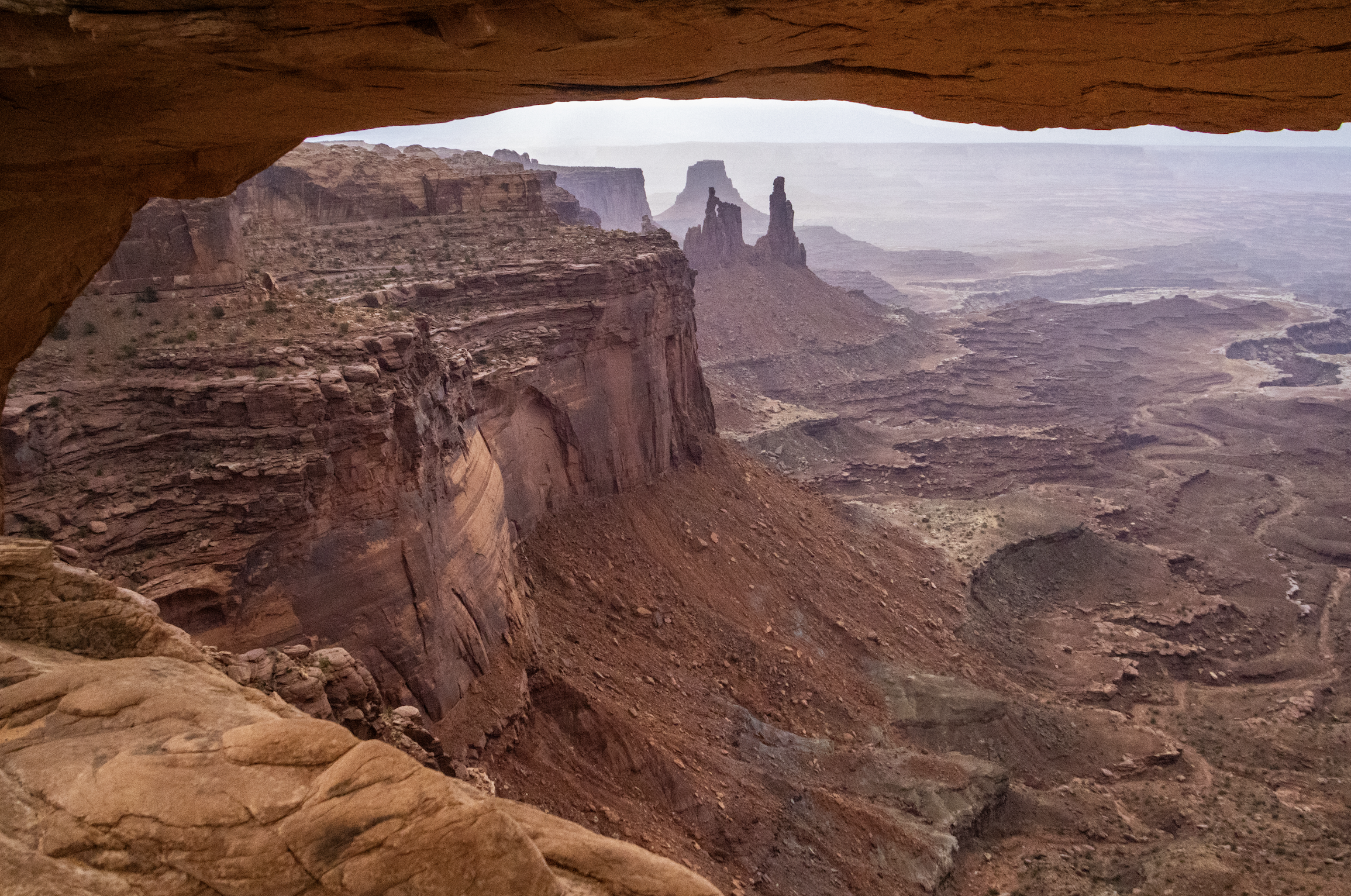
Finally, we arrive at Canyonlands National Park, which is the largest and most remote place we will visit on this trip by far. A couple hours southwest of Moab and Arches, Canyonlands spans an area of more than 300,000 acres. It is not a place that can be seen fully in a single day… but we’re going to do our best. Indeed, this particular trip will be most confined to the northern regions of the park, but I want to underscore that there is a LOT more of this landscape that we won’t see today.
As you will see, Canyonlands is a VAST area of canyons carved by mighty rivers that still flow through them to this day. Thousands of feet above the water, towering mesas look out across seemingly endless canyon-scapes. It offers more than a few STUNNING views.
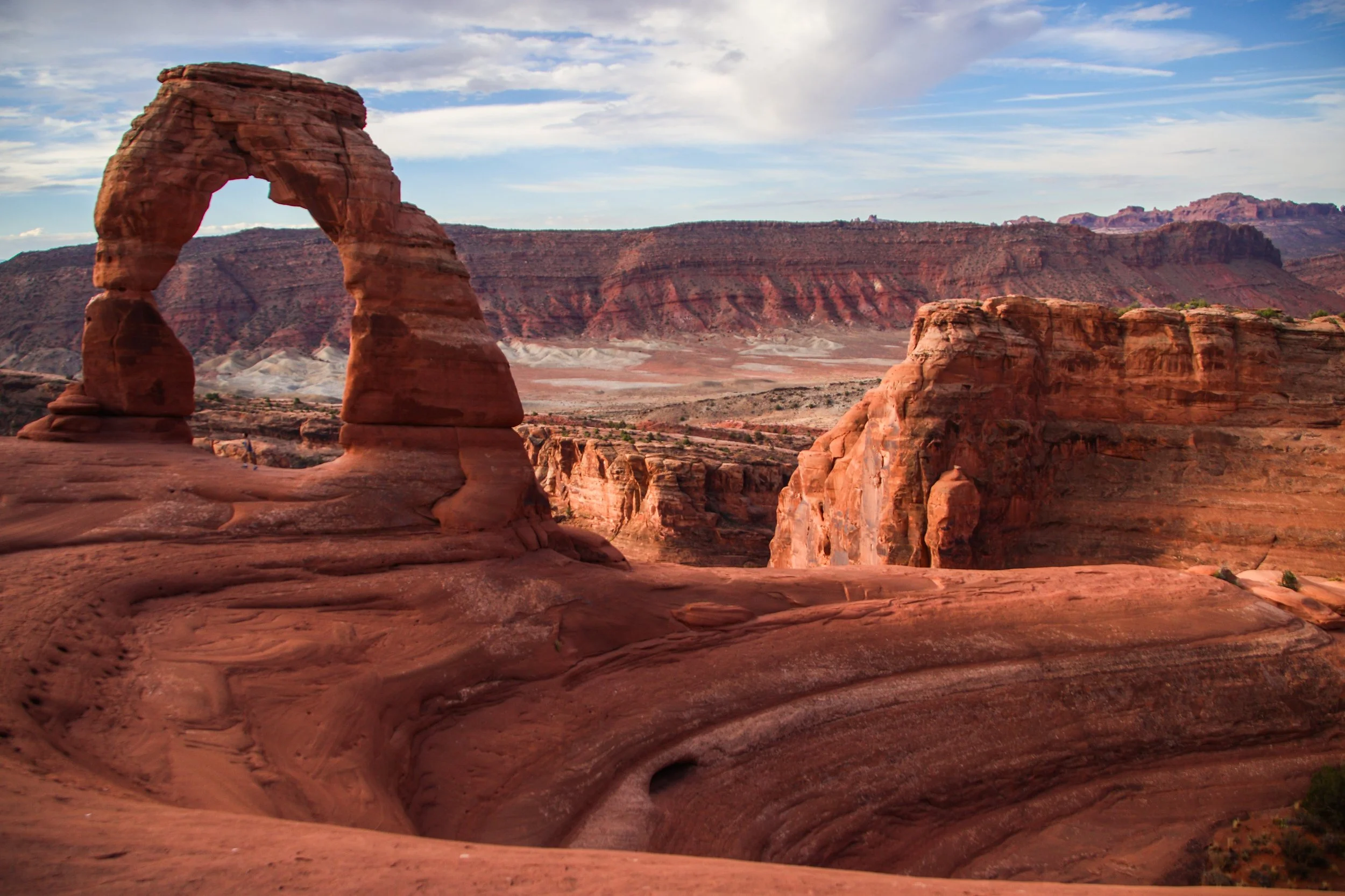
There are lots of famous rock formations in Arches National Park, but the most famous of them all is called “Delicate Arch”. We wanted to get there early in the day and experience sunrise within the park, which meant that we have to get moving at the butt-crack of dawn. In the gentle early morning light, our rental car carried us out of Moab and up a steep switch-back road into the park. Mind you that Moab is already ~4,025 ft (1,227 m) above sea-level. Arches actually gets as high as ~5,653 ft (~1,723 m) above sea-level, and—despite being only ~5 miles (8 km) away from downtown Moab—is usually 5–10°F (~3-6° C) colder. That being said, both Moab and Arches get HOT in the summer. The record high in Moab was 114°F (~46°C), and summer highs frequently exceed in 100°F (38°C) within Arches. So, heat is a hazard here! Consequently, sunrise/sunset exploration tends to be preferred, with many visitors retreating to Moab for a nice air-conditioned siesta in the middle of the day.
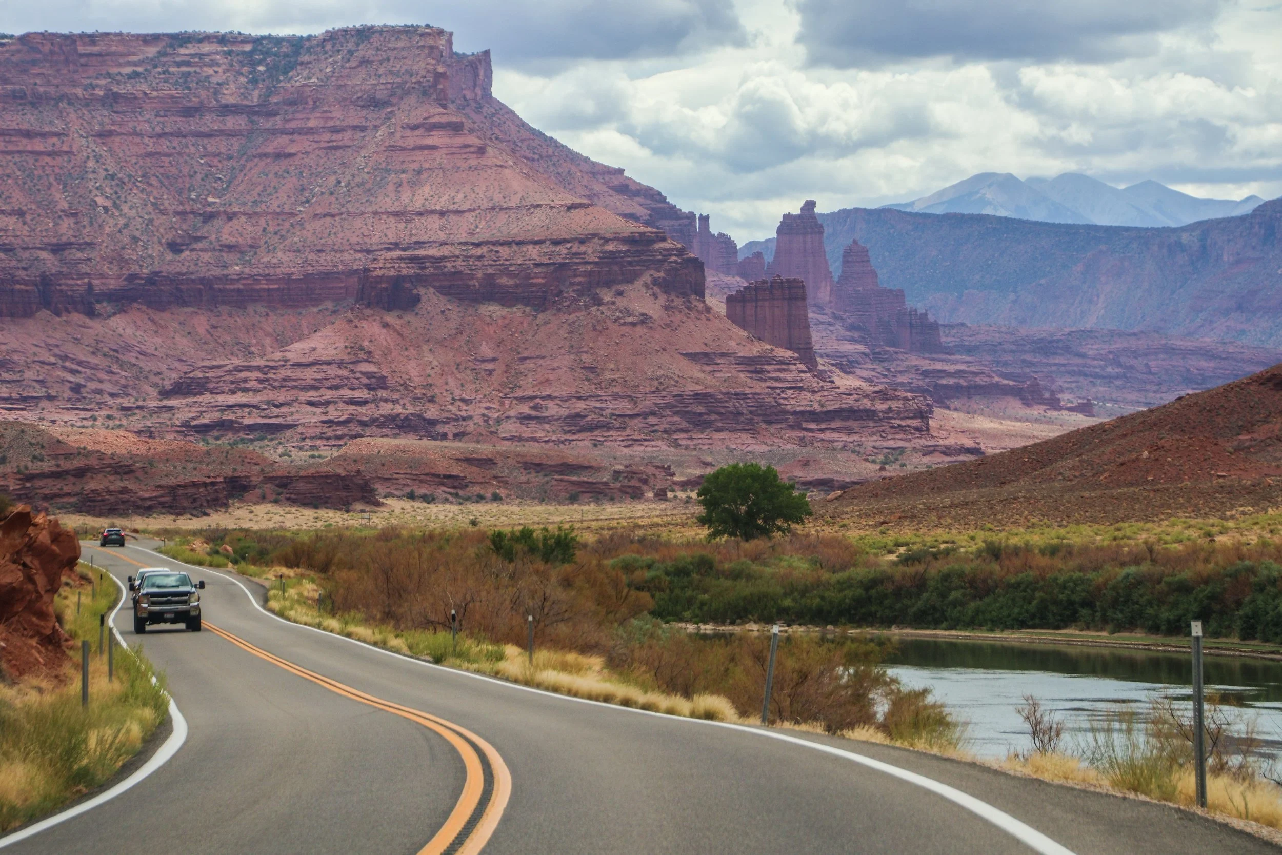
The road you are about to see was an important regional access point long before Moab was ✨M0aB✨—it was (and still is) important for ranching and river access. AND, it was apparently an important area for Uranium mining in the mid-1900s. But the human element of this road is really besides the point; unlike the rigid grid systems you will find in a lot of US infrastructure, this road works with nature, snaking through this canyon, following the river wherever it goes. In this sort of geography, you’d really have no choice but to build this road this way. That’s one of the magical things about traveling out west: the natural features become far too big for humans to tame.
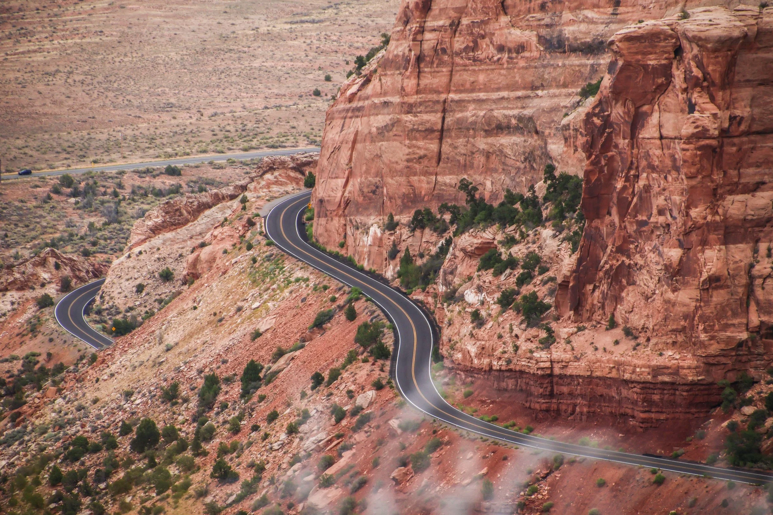
Colorado National Monument isn’t a single landmark, but a large area of landscape, which includes massive rock formations, deep canyons, and rugged plateaus, all of which were carved over millions of years by wind and water. The primary thing to do here is the Rim Rock Drive, which is a 23-mile-long paved road that brings you past a great many breathtaking views over dramatic sheer cliffs and expansive valleys. There are lots of places to stop along the way, many of which have their own hiking trails and camp sites. Today, we’re going to drive the Rim Rock Road.
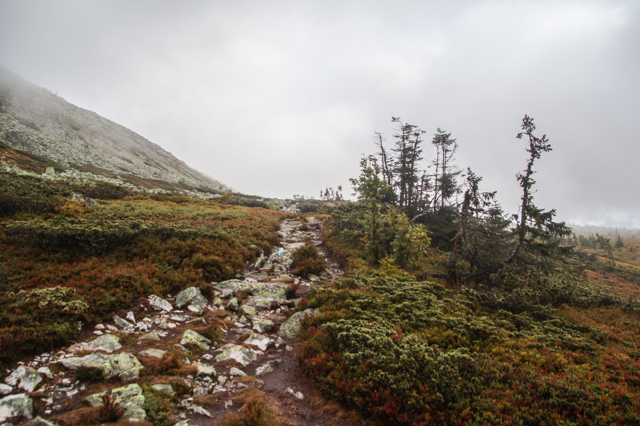
I was excited to see some of Norway’s legendary mountains! Unfortunately, Freyr (the Norse god of good weather) was otherwise occupied during my visit. During our entire stay in Trysil, the landscape was covered in a thick fog and a cold, driving rain. It was perfect weather to cuddle up with a good book in a mountain cabin… but we had other plans.
Bright and early, we set out into the cold, foggy wetness to complete our hike. There were about 5 minutes where the sun managed to poke through the cloud cover, so I’ll show you those photos first. We were not in a particularly scenic part of the trail during that fleeting moment, but even then it was clear that—had we been able to see the landscape around us—it would have been incredible. The sun reveals a stunningly bright color palette on the grass around us.
Maasai Mara—which is often locally referred to as simply, “The Mara”—is the name of a giant nature preserve in southwest Kenya. Its namesake, the Mara River, runs through it, and the word “Maasai” refers to the original tribal inhabitants of this area, who can still be found here today.
Well, as far as I know, the only difference between Maasai Mara and the Serengeti is the border between Kenya and Tanzania. The Mara is the Kenyan side, while the Serengeti is the Tanzanian side. Looking at the map, it might be tempting to think that Maasai Mara is the lesser of the two experiences because it’s so much smaller than the Serengeti, but—while I have not personally experienced both—I’m told this is not the case.
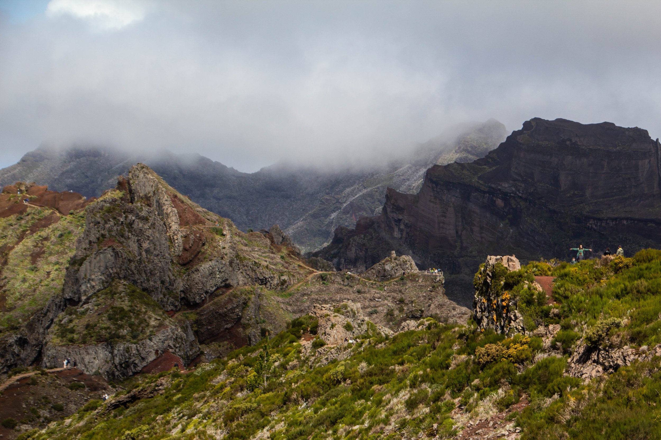
The #1 rated hike in Madeira on AllTrails is the one that from Pico do Areeiro to Pico Ruivo. These are the two highest peaks on Madeira. And in the middle you pass over Madeira’s 3rd highest peak: Pico das Torres. AllTrails ranks this hike as “Hard” and I think most people who do it would agree. But there’s some serious hype around this trek!
“It’s gonna be the coolest hike of your life” my friend said to me confidently after we landed in Madeira.
“…Like, my life specifically?” **Subtext: “You don’t think I’ve done any other cool hikes?” 🥺
“No, dude, like the coolest hike of anyone’s life.”